Thursday 28 March 2013

Namibia

http://en.wikipedia.org/wiki/Namibia

Namibian dollar exchange rate on a par with South African Rand.
AU$ 1 = NA$ 9.50

Walvis Bay
There was a very refreshing lack of the formidable security that is so omnipresent in South Africa. Some of the houses were fenced or walled but there was very little razor wire, electric fences and "Armed Response" security signs around. 

Flamingos in Walvis Bay Lagoon
More work on the boat - fixing diesel leaks and servicing the engine. Olli had a good laugh at my expense, when over a beer, I referred to all the leaks on the boat. He suggested I should rename the boat "Leak". Oh, if it was not so true.

After "Fagel Bla" departed for St Helena I met up with Mac and his kids on "Moonbeam" a beautiful 45' Schooner. I'd had met Mac in East London while I was there.

I hired a car and had the pleasure of Mac and the "Moonbeam" crew for a visit to Swakopmund - 35 Ks north of Walvis Bay. I was surprised at the housing developments along the coast - very extensive and expensive. The huge sand dunes extend about 2 kilometres inland. I would have liked to explore more of Namibia but alas the budget had taken a severe beating in South Africa and I was keen to head to warmer waters. Like Madagascar it would be worth a second visit. 

Where the desert meets the sea
All to soon it was time to leave. Walvis Bay was a good place to provision the boat. I was able to get small single servings of meat vacuum packed for the trip. There was good fresh produce, unfortunately it had been chilled so would not last very long. Most fresh produce seems to come from South Africa. The Walvis Bay Yacht Club was very friendly and Linda the club manager was very helpful.

It is not very often that one gets to see a sunrise along the Namibian coast with the all pervading fog. On the day of departure the winds were calm, temperature mild and the sun rose. 

Sunrise over Walvis Bay

Saturday 16 March 2013

Cape Town to Walvis Bay, Namibia

Saturday March 9, 0800 Sadiqi departed leisurely from Cape Town Harbour after requesting permission to leave from Port Control on Ch14.
Engine: 1185.6 Hrs. Log 8894.6 NM. The wind was 10 to 15 knots from the South East. The swell to 4 metres. 

Good Bye Cape Town
Noon 09-03-13 – Saturday
Time: 12.00L UTC+2.0 
Lat: 33 36.22 S
Lon: 018 17.66 E
COG: 0 Deg  M, SOG 5.5 knots
Winds: 10 to 15  Kts S, Swell to 4 meters .
Engine: 1186.3 Hrs
Distance covered since departing Cape Town 20.3 Miles.

It was so good to be sailing again.
Everything appears to be working onboard. The skipper felt a little queasy with the previous days brunch threatening to make a reappearance.
Cold!

1730 - Spoke to Andrew on Peri Peri Net.

1830 - Abeam Saldanha Bay.
Winds 20 to 25 Kts SE. Swell 4 to 5 metres. Rolling along at 5 to 6 knots.

10-03-13 – Sunday
Noon
Time: 12.00L UTC+2.0 
Lat: 31 36.81 S
Lon: 017 03.94 E
COG: 0 Deg  M, SOG 5.5 knots
Winds: 10 to 15  Kts SE, Swell to 4 meters .
Engine: 1186.3 Hrs
Distance covered since noon yesterday 134 Miles.
Cold, clear skies good visibility. Rolling along at 5 to 6 knots.

11-03-13 – Monday
0600 Winds dropped 10 -12 Kts SE
SOG dropped to 3 kts. In counter current south of Orange River.
Started engine.
COG 350 Deg M, SOG 4 Kts.

1020 Winds 10 - 12 kts SW - turned off engine.

Noon
Time: 12.00L UTC+2.0 
Lat: 29 45.35 S
Lon: 016 03.64 E
COG:330 Deg  M, SOG 4.5 knots
Winds: 10 to 12  Kts SW, Swell to 4 meters .
Engine: 1191.4 Hrs
Distance covered since noon yesterday 123 Miles.
Pushing against a half knot counter current.
Getting warmer.

1700 Wind 5 - 8 Kts SW
Tried to fly Asymmetrical Big Bertha - SOG 3 Kts.
The seas were a little too lumpy to fly Big Bertha. Started engine.
Visibility around was 3 miles. The AIS indicated a ship approaching Sadiqi's position. The large container ship was not visible until it was 3 miles away.

12-03-13 – Tuesday
0230 Winds 10 -12 Kts SW
Thick Fog - wet and eerie. Turned off the engine.
Sailing SOG 4 to 5 kts. Radar on and guard zones activated. It would appear most South African fishing boats have AIS transponders, understandable given the occurrence of fog on this coast due to the frigid Benguela current. 

Noon
Time: 12.00L UTC+2.0 
Lat: 28 23.52 S
Lon: 014 35.91 E
COG: 10 Deg  M, SOG 5 knots
Winds: 10 to 15  Kts S, Swell to 2 meters .
Engine: 1203.8 Hrs
Distance covered since noon yesterday 112 Miles.

Rolling along

2300 Winds 18 - 23 Kts. Swell 3.5 m.
GPS chart plotter loosing fixes and resetting periodically - not sure why. Maybe, it or the batteries are feeling the cold like the skipper. Water Temperature between 13 and 16 degrees C. A lot of inane chatting and noises on VHF channel 16 at night.

13-03-13 – Wednesday
0630 45 miles due west of Luderitz. The plan had been to stop at Luderitz. Skipper decided to stay longer at Walvis Bay instead and hopefully do some exploring.
Wind 18 - 23 Kts SSE
COG 5 Deg M, SOC 5.5  Kts.
Cold and damp!

1000 Winds 8 - 12 Kts S.
Started engine to charge batteries.
1030 Winds 12 - 18 Kts SW. Stopped engine.

Noon
Time: 12.00L UTC+2.0 
Lat: 26 13.99 S
Lon: 014 04.52 E
COG: 350 Deg  M, SOG 5.5 knots
Winds: 12 to 15  Kts S. Swell to 2.5 meters .
Engine: 1205.4 Hrs
Distance covered since noon yesterday 132.5 Miles.

It was a another moonless, bitterly cold and damp night.
Winds varied between 18 and 23 knots from the south or south east.
The GPS plotter did not think much of the cold and damp as it continued to loose it's satellite fixes and reset.

14-03-13 – Thursday
It was a bright sunny morning with very little wind. I felt better for it and it would appear so to did the GPS Plotter which worked happily.

Noon
Time: 12.00L UTC+2.0 
Lat: 24 12.81 S
Lon: 013 51.76 E
COG: 30 Deg  M, SOG 3.5 knots
Winds: not much - 5  Kts E. Swell to 2 meters .
Engine: 1207.5 Hrs
Distance covered since noon yesterday 122 Miles.
Engine running.

By evening after the Peri Peri Radio net sched the winds picked up and Sadiqi was sailing with just a partially furled main, doing 4 to 5 knots.

Most of the time Sadiqi had been sailing about 40 to 50 miles off the coast. The skippers thinking was that it was better to be where the big ships were steaming with AIS transponders as opposed to the fishing boats with no AIS, or with AIS receivers only like Sadiqi. This assumed of course that all ships over 300 tonnes had AIS transponders. There were a good number of fishing boats plying the waters off the coast. Most of them without AIS transponders. It was very nerve wracking on closing the coast near Walvis Bay in the fog knowing the fishing boats were there and not being able to see them. Most small fishing boats are made of wood or fibreglass, which is difficult to see on radar.  

15-03-13 – Friday
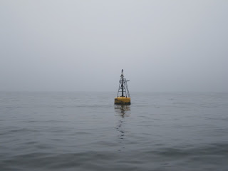
By around 0800 hours Sadiqi was motoring in flat waters and thick fog within a mile of Pelican Point. I thought that I may catch a glimpse of Namibia at that distance. This was not to be. The first glimpse was of a forlorn North Cardinal buoy. Fur Seals gambolled about in Sadiqi's wake.  


North Cardinal Buoy and Bell
1000 Sadiqi arrived at Walvis Bay Yacht Club anchorage.
Winds: 0 to 2 knots SW.
Engine: 1207.5 Hrs
Distance covered since noon yesterday 90 Miles.

Roxy the new Rocna anchor was christened and commissioned.
On shutting down the engine I noticed diesel was leaking from around the lift pump and injector pump.

I saw yacht "Fagel Bla" from Finland in the anchorage. I had met Olli and Merja in Hout Bay. There was an abundance of bird life around the bay - Flamingos, Pelicans, Cormorants (flying arseholes), gulls etc.

The skipper hauled out the inflatable dingy and outboard, neither of which had been used in nearly 6 months - last time in Mozambique. The dingy floated and the outboard started, both conveyed the skipper to the yacht club. After a much needed shower the skipper went in search for officialdom to do the required entry documentation.

It was a lengthy walk to the town. I was very pleasantly surprised and how clean, neat and tidy Walvis Bay town was. The passport was stamped with a minimum of hassle. 


Flamingos
On returning to the dingy I looked out toward Sadiqi and noticed she had moved! Olli from Fagel Bla met me on the way out. Sadiqi had dragged and was tied to Olli's boat on a long line. I was very grateful to Olli and Merja for arresting Sadiqi's escape downwind.  Olli, knew I had bought a new anchor and had a good laugh at my expense. The fault was mine in that I had not let enough scope out when laying the anchor. As tired as I was I went ashore that evening and bought Olli and Merja drinks at the yacht club in a gesture of gratitude for halting my anchor dragging boat. Another lesson learned.
----------
radio email processed by SailMail
for information see: http://www.sailmail.com

Saturday 9 March 2013

Leaving Cape Town


Fairly early Saturday, March 2 I waved goodbye to friends and sadly departed from Hout Bay Marina. I had the pleasure of sail training student, Mario, as crew. Mario, needed a lift round to Royal Cape Yacht Club for a race in the afternoon. A few blasts of 35 knot winds off Chapman's Peak helped us out of the Bay. In the lee of the land heading north the winds were calmer, to the point of having to start the engine as we neared Cape Town Harbour. Mario very adeptly navigated Sadiqi through the inner harbours to the marina, having been into the harbour before.


A recent ruling requires all sailing vessels to clear out of Royal Cape Yacht Club. The Yacht Club charges 1,000 rand (AU$125) for the privilege.

I cleared out of South Africa on Wednesday March 6 visiting: Port Control, Immigration and Customs. I had planned on departing Cape Town on the Thursday. However, there was very little wind from the north and a 4 metre swell. I decided to stay until Saturday when the winds were forecast to be 15 to 20 knots from the right direction - southerly.

With a severely depleted wallet I was happy to leave the shops and chandleries behind.

Friday 1 March 2013

Climbing Table Mountain

My time in Cape Town was running out. I persuaded Saskai, who persuaded her daughter Melisa, to walk up Table Mountain. Melisa had done the climb several times with friends and led the way taking us up the one of the most difficult climbs "Indian Venster" route. On nearing the top and seeing the signs warning people that this was a dangerous route I did wonder what I had been thinking to do the climb with youngsters again. It was one of the most challenging climbs I have done. On reaching the top we discovered that the Cable Car was not operating due to strong winds. I was so hoping to travel down by cable car. The wind was strong and icy cold at the top of the mountain.
Cape Town from lower Cable Car Station
 Lions Head
Protea
Pole Dancing on the mountain - the sign says it all
The summit looking down at lower Cable Car Station and Cape Town

Down Platteklip Gorge Route
On the way down we chose the easier Platteklip Gorge Route. By the time we reached the bottom, some 5 hours after starting the ascent, my legs were like jelly. The upper Cable Car station is 1050 metres above sea level. After a substantial breakfast and with aching muscles we all had an afternoon nap.